Hello,
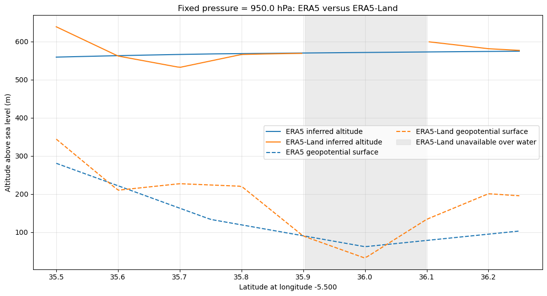
I am comparing ERA5 and ERA5-Land surface pressure along a transect to understand the effect of the different model orographies.
I downloaded:
- ERA5 hourly single-level data;
- ERA5-Land hourly data;
- ERA5 geopotential;
- ERA5-Land invariant geopotential.
The transect is approximately:
- longitude: −5.5°;
- latitude: 35.5–36.25°;
- time: 15 July 2020, 12:00 UTC;
- fixed logger pressure: 950 hPa.
I convert geopotential \(\Phi\) to surface elevation as:
\[ z_{\mathrm{surface}} = \frac{\Phi}{g}, \]
with \(g=9.80665\ \mathrm{m\,s^{-2}}\).
I then estimate altitude from the fixed pressure using:
\[ z_{\mathrm{logger}} = z_{\mathrm{surface}}+ \frac{T}{L} \left[ \left( \frac{P_{\mathrm{logger}}}{P_{\mathrm{surface}}} \right)^{-R_dL/g} -1 \right], \]
where \(T\) is 2 m temperature, \(L=0.0065\ \mathrm{K\,m^{-1}}\), and \(R_d=287.05\ \mathrm{J\,kg^{-1}\,K^{-1}}\).
Over land, I obtain:
- maximum difference in geopotential-derived surface elevation: approximately 106 m;
- maximum difference in inferred altitude for the same fixed pressure: approximately 80 m;
- maximum difference between the ERA5–ERA5-Land pressure difference and the pressure difference expected from the elevation difference: approximately 8.9 hPa.
ERA5-Land is unavailable over the water section of the transect, which explains the missing values there. The comparison above is based only on locations where ERA5-Land provides data.
My understanding is that ERA5-Land pressure is obtained by interpolating ERA5 atmospheric fields to the finer grid and applying an orographic/lapse-rate correction. The documentation describes temperature, pressure, and humidity corrections for the elevation difference between the ERA5 and ERA5-Land grids:
Could you clarify whether differences of approximately 80–100 m in the inferred altitude are expected and physically normal in this situation?
In particular:
- Should ERA5 and ERA5-Land surface pressure, temperature, and geopotential reproduce approximately the same altitude after applying the hydrostatic equation?
- Is the pressure correction in ERA5-Land expected to satisfy the simple hydrostatic equation using the published 2 m temperature and geopotential?
- Could the difference be caused by the use of a daily environmental lapse rate, rather than the instantaneous 2 m temperature?
- Is it valid to use the ERA5-Land invariant geopotential together with ERA5-Land surface pressure and 2 m temperature for this calculation?
- Are there additional corrections or differences between the model geopotential and the pressure-correction geopotential that should be considered?
I can provide the exact NetCDF extracts, the Python download/calculation script, and the resulting transect table if useful.