Hi,
sorry it might be a bit confusing. As stated ERA5 HRES native grid is on a 0.36 degrees reduced latitude/longitude grid.
i.e. reduced latitude/longitude grid
NOT a reduced Gaussian grid (the coupled wave model does not share the same grid with the atmosphere)
So what is the difference:
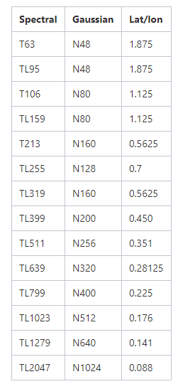
A Gaussian grid has its latitudes set by 'the T-number'
It is then reduced, by specifying the number of grid points for each latitude in order to limit the convergence in actual distance near the poles.
A reduced latitude/longitude grid on the other hand, has its latitudes evenly spaced (0.36 degrees in the case of ERA5 HRES),
and it is reduced in a similar fashion as the Gaussian grid so that the number of points per latitude is set so that the actual distance between grid points
is kept roughly constant, equal to the distance spacing between latitudes (0.36 degrees → 40 km).
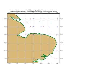
For the actual position of the model grid points, one will need to get from the grib headers, the number of points per latitude N(j), j=1,Ny
where Ny is the number of latitudes in the grid. For each latitude j, the spacing in degrees is then 360/N(j), with the first point starting at 0, wrapping around the latitude, with the last point at 360 - 360/N(j)
SO in short, the resolution of the native grid for ERA5 HRES is ~ 40km
NOTE: this is for the native grid. Most users will only access the default data from the CDS which have already been pre-interpolated onto a REGULAR latitude-longitude grid of 0.5x0.5 degree (i.e. grid point equally spaced)
To get the native grid data, one needs to fetch the data from the mars tape archive which is not usually recommended but feasible (Please as the CDS help desk). Also note that the in-house converter grib to netcdf does NOT work with native grid wave data and so it is then best to request the data to be interpolated on a 0.36x0.36 regular lat/lon grid before conversion from grib to netcdf.