Hi guys,
I used that nice script Compute geopotential on model levels to compute the geopotential height on model levels of some ERA5 data. In doing so, I came across some strange behavior: At those locations on Earth where the orography has negative geopotential height values, the geopotential of the model levels decreases (gets more negative) when going upward in the atmosphere (from model level 137 to 0). Did anybody else came across that? Does anybody know how to fix that?
Thanks,
Amelie
Hi Amelie,
Could you please give us some examples of the behaviour you mention? You can let us know what data you have downloaded from ERA5 and they way you call the script.
Thanks!
Cristian
Hi Cristian,
I'm sorry, I've just realized that I had a bug in my script analysing the results. It's everything fine with the script! Geopotential height increases everywhere when going upward in the atmosphere. I'm sorry for my mistake. But anyway, thanks for your quick support.
Cheers,
Amelie
Hi Cristian,
I have met an issue that I download the ERA5-pressure-levels data, but I can't find the way to calculate geopotential height in ERA5-pressure-levels. Although there are examples to calculate height in interim and model level, but the single-level is 37 pressure levels, the methods in the documentation seems to be 60 levels. Do you know how to calculate the height in ERA5-single-levels ? I also find some model definitions, but I can't find the definition that suit 37 levels.
Hi,
you can download the geopotential (m2 s-2) on all the 37 pressure levels and compute the geopotential height (m) dividing the geopotential values by the WMO-defined gravity constant of 9.80665 ms-2, which is constant for all latitudes and all heights.
Regards
Michela
Hi, Michela,
Thank you for your advice, the problem has been solved.
Best regards
Thanks!
Dear all,
when calculating geopotential on model levels with
the script uses the “moist temperature”.
Line 220 says: t_level = t_level * (1. + 0.609133 * q_level) with q_level as specific humidity.
But wouldn’t it be more accurate to use the Total Water Content instead of specific humidity?
I.e. shouldn’t line 220 look like: t_level = t_level * (1.+0.609133*q_level - ql_level - qi_level) where ql_level and qi_level refers to liquid water and ice water, respectively?
Or would this introduce some inconsistency with the model formulations?
Best,
Heimo
When calculating geopotential on model levels one has to take into account the model formulation: in ERA5 (CY41R2) and other older IFS versions, the documentation (Part III: Dynamics and Numerical Procedures, https://www.ecmwf.int/sites/default/files/elibrary/2016/79696-ifs-documentation-cy41r2-part-iii-dynamics-and-numerical-procedures_1.pdf, page 5, last line) says:

That means, that liquid water and ice are ignored in the formulation of the model equations. Hence, one would introduce an inconsistency with the model formulation when making use of these water species in the calculation of the geopotential.
However, in recent model versions the documentation (https://www.ecmwf.int/sites/default/files/elibrary/112024/81625-ifs-documentation-cy49r1-part-iii-dynamics-and-numerical-procedures.pdf), page 5, last line) says:
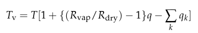 where qk denotes cloud liquid water, ice, rain, and snow.
So, when I calculate geopotential on model levels from current IFS data, I would also take liquid water, ice, rain, and snow into account.