Hi all !
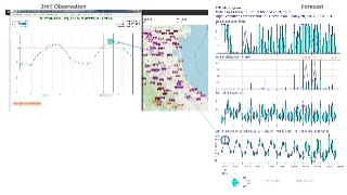
I would like to report a kind of systematic error associated with the current heat-wave in Europe. I noticed that 2m maximum temperatures during the heat-wave peak in Northern Italy have been overpredicted. Especially in the Emilia-Romagna region where, according to model output, we were expecting Tmax on Sunday largely over 35°C. On average Tmax reached 34°C, when ECMWF 2mT forecast, especially 2-3days before, was reaching maximum values of 38°C in the same places. The error, although reduced, persisted also in the very short-term forecast (+12h). This overestimate was uniform on all the flat areas of this region.
I attach here two slides: the first is showing a comparison of observed 2m T at the synop (and RSD) station ground of S.Pietro Capofiume, in the countryside near Bologna (no urban influence here), against the ECMWF forecast interpolated in a point very close (the same municipality, flat terrain, same conditions). A difference of about 2°C is still visible in the interpolated forecast in the very short term forecast ( +12h). Normally you would expect, if anything, an underestimate due to spatial interpolation and temporal smoothing of the maxima.
The second slide is showing a comparison, over the same position, of the radiosounding of yesterday at 12:00UTC. In this slide I'm pointing to a small (and weird) isothermal layer present in the sounding which breaks the adiabatic (decrease/increase) of temperature with altitude, not present in the corresponding forecasted vertical profile at the same point. I guess it would be interesting better understanding these differences in order to exclude some systematic misrepresentation. Is there some process missing or a "simple" difference in radiation due to clouds ? There were clouds around, especially an extended cirrus deck. But this seems to be present as well also in the predicted vertical profile.
Cheers,
Federico Grazzini


