Hello,
I am using CORDEX regional climate model data (“projections-Cordex single levels”) for the location Tounj over the historical period 1971-2000. My ensemble consists of 4 GCM-RCM combinations:
• MPI-ESM-LR × REMO2009,
• EC-EARTH × CCLM4-8-17,
• HadGEM2-ES × REMO2015,
• IPSL-CM5A-MR × RCA4.
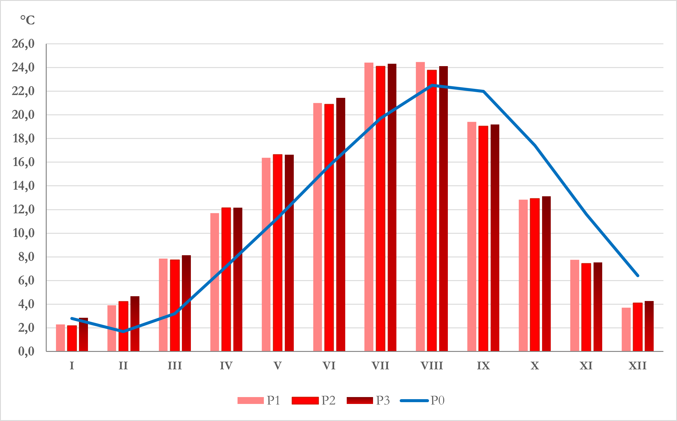
From the data, I generated monthly mean temperature charts. When comparing the historical averages with observational data from DHMZ (Croatia) and reanalysis ERA (for the same location/region), I find February is warmer than January, consistent with observed climate norms. However, the CORDEX ensemble yields that January is warmer than February in the reference period 1971-2000 — which seems contradictory. I attach also chart I made based on the CORDEX data.
My questions are:
Is it possible there is a shift in the ‘time’ coordinate or in calendar labeling (e.g. a calendar attribute: Gregorian vs no-leap) in the NetCDF / Copernicus files, so that February and January might be misaligned?
Do the CORDEX models for this region use the full Gregorian calendar, or a variant (e.g. no-leap) that omits certain days/years and might cause the first time[0] to start at 1971-02-… instead of 1971-01-…?
Is there documentation or a user guide noting that the historical series for some models are incomplete for the first or last year (e.g. missing January in 1971) for certain grid points?
Thank you in advance for your assistance and for clarifying this.
Hi, thanks for your interest in the C3S CORDEX data.
Could you confirm whether you are using the daily data from the CDS and computing the monthly means yourself, or downloading monthly mean directly?
[1] Based on the plot you show, if blue is the mean climatology of the four CORDEX models it does seem like the time axis has been shifted by one month. You can see a plot of Croatia made using the C3S Atlas here (which uses the same CDS data with post-processing applied), and you can see that January is cooler than February, as you are expecting: Copernicus Interactive Climate Atlas
[2] The calendars used by different climate models do vary (and are sometimes specified in file metadata or model documentation), however the time coordinate and corresponding bounds for the averaging and accumulation periods should still be accurate.
[3] There is no list which specifies whether there are missing days or months at either end of the historical period for different datasets, but it should be clear from the time coordinate or the corresponding bounds. If January 1971 was missing, it would be missing for all grid points, as the time-slice will simply not be available in the file.
We hope this helps, and are happy to try and help further!