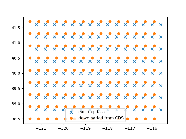
I used the CDS app web interface to fetch CAMS global forecast data, but the data I got was on a grid which didn't match what I expected.
It seems that the new data I got from CDS was for some reason shifted so that the bottom left corner exactly matches the bottom left corner of the area I requested.
I have another dataset of CAMS global forecast data for about the same area, and the datasets are not aligned. The two datasets I have don't contain the same parameters so I don't know if the parameters' values were interpolated to a new grid or left as-is.
My question:
What is the expected behavior of the CDS app when requesting for a specific area? should I specifically align the area I ask for with the CAMS global grid?
Thank you
Below is some more information to explain the issue.
My CDS form was translated into the following API request:
c.retrieve( 'cams-global-atmospheric-composition-forecasts', { 'date': '2021-07-08/2021-07-12', 'type': 'forecast', 'format': 'netcdf_zip', 'variable': [ 'organic_matter_aerosol_optical_depth_550nm', 'sulphate_aerosol_optical_depth_550nm', ], 'time': [ '00:00', '12:00', ], 'leadtime_hour': [ '0', '1', '10', '11', '12', '13', '14', '15', '16', '17', '18', '19', '2', '20', '21', '22', '23', '24', '25', '26', '27', '28', '29', '3', '30', '4', '5', '6', '7', '8', '9', ], 'area': [ 41.97, -121.51, 38.53, -115.53, ], }, 'download.netcdf_zip')
A sample of the resulting coordinates:
     latitude  longitude

  0       41.73    -121.51

  1       41.33    -121.51

  2       40.93    -121.51

  3       40.53    -121.51

  4       40.13    -121.51

  ..        ...        ...

  130     40.13    -115.91

  131     39.73    -115.91

  132     39.33    -115.91

  133     38.93    -115.91

  134     38.53    -115.91
And this is how it looks on a plot (x=lon, y=lat), comparing the data I had before ("existing data") and the new one I got from CDS ("downloaded from CDS"):