I need to check the water depth of the data points I downloaded but cannot find this information in the user manual. Perhaps I’m looking in the wrong place? Does anyone know the water depth data source used by ERA5? Any help would be greatly appreciated!
Not sure what ERA5 Is using, but you can get bathymetry data from the Copernicus Marine Data Store: Global Ocean Waves Analysis and Forecast | Copernicus Marine Service
1 Like
Hello ![]()
According to Section 6.9 of IFS Documentation CY41R2 - Part VII: ECMWF Wave Model | ECMWF, “An updated version of the high resolution bathymetry data file (ETOPO2) was used to derive the model mean bathymetry and the sub-grid blocking factors in all configurations”.
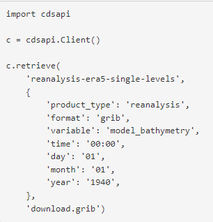
To access the data from the CDS you can use the download form Copernicus Climate Data Store | Copernicus Climate Data Store or the API
All the best
Rémi
1 Like
If the question was about the water depth used by the wave model in ERA5, Remi’s answer is correct. The data used to produced the ERA5 bathymetry for the wave model indeed come from ETOPO2. As Remi has indicated, it is a parameter that is available from the data store.
If instead, the question was related to the water used by the lake model, than one would need to retrieve the lake depth parameter.
Note that I would be careful to interpret the value of the bathymetry obtain from the CDS as what was used by the model because by default the data have been interpolated and hence the bathymetry hence retrieved would not necessarily correspond to what was used at each grid point of the native grid.
2 Likes
Thank you for your detailed answer. This indeed addressed my question.